Digital Solutions for Voyage Optimization
WEATHER ROUTING
Route planning and voyage optimisation juggle various constraints, including safety, operations, and compliance. Ship captains face this essential and complex task, which demands a reliable decision-support tool to guide their choices and ensure smooth execution. To address this need, Ascenz Marorka designed an advanced route optimisation solution that advises the best route by optimising numerous parameters while respecting operational constraints. This tool suits all vessel types (tankers, bulkers, container vessels) and propulsion or fuel types. Moreover, when combined with the other features of Ascenz Marorka’s Platform, it becomes a powerful resource for stakeholders to collaborate and achieve operational and economic goals.

Optimisation Options
Among the optimisation options, key considerations include:
- Voyage duration
- Voyage distance
- Fuel consumption
- Cost (including fuel, daily expenses, canal fees, carbon taxes, etc.)
- Emissions (considering fuel-specific conversion factors)
- Ship motions (e.g., parametric/asynchronous rolling, surf-riding, successive high-wave attacks)
Advanced Features for LNG Carriers
For LNG carriers, specific advanced features include:
- Sloshing prediction
- LNG cargo loss prediction (while complying with discharge terminal constraints)
The algorithm offers high flexibility and can be customised with any cost function for optimisation.
Constraints Considered
Additionally, the algorithm accounts for numerous constraints:
- Ship dimensions for navigational limitations
- Weather conditions (wave height, wind speed)
- Forbidden power/speed ranges
- Cargo types (for international and local route restrictions)
- Special areas (with maximum/minimum speed or no-go zones)
- Traffic Separation Schemes
- Maximum Carbon Intensity Index (CII)
CII Management
The Voyage Optimisation module and the overall platform provide features essential for managing CII regulations. New rules require shipowners and charterers to collaborate closely to monitor and optimise the vessel’s CII score. If the score drops below the agreed limit, contractual clauses demand corrective measures. The route optimisation module plays a crucial role by offering predictive capabilities (fuel consumption, CII, distance) and serving as a collaborative platform for all parties.
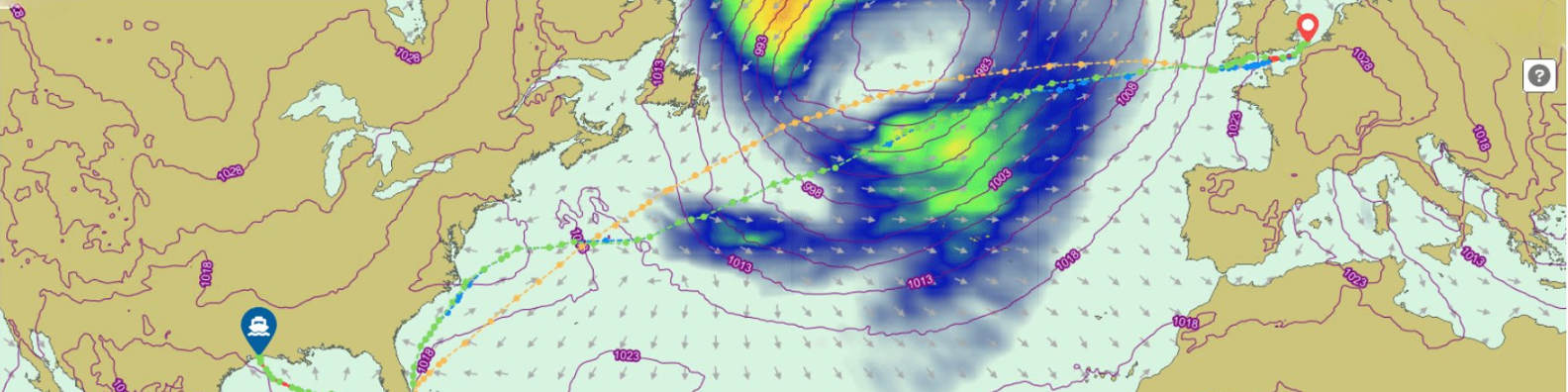
Route Variations
Depending on the selected optimisation criteria, route variations can be significant. For example, in one simulation, three routes were plotted:
- Least fuel (orange)
- Shortest distance (purple)
- Lowest total cost (blue)
In this case, the “lowest cost” scenario achieved a 10% saving compared to the “shortest distance” scenario, taking daily costs, fuel prices, and speed ranges into account.
Digital Twin and Environmental Conditions
To ensure accurate advice, the software uses the vessel’s digital twin, built using available data such as dimensions, sea trials, noon reports, maintenance records, and sensor data. This model factors in both operational and environmental conditions, such as draft, speed, and weather.
Constant Power Profiles
For optimal performance, the algorithm prioritises constant power profiles. When facing adverse conditions like strong winds or high waves, vessels must consume more fuel to maintain speed. Instead of allowing spikes in fuel consumption, the software recommends an RPM that stabilises power and fuel use while adhering to commercial constraints.
Traffic Separation Schemes
The solution incorporates up-to-date Traffic Separation Schemes to generate realistic, crew-ready routes. This reduces the captain’s workload, ensures trust in the suggested routes, and minimises deviations from performance goals.
VOYAGE MONITORING AND ANALYSIS
Onboard and online, the software provides live recommendations for optimal shaft speed, GPS speed, and trim settings. A smart comparison between the actual vessel route and the suggested optimal route is displayed, summarising performance and savings.
VOYAGE MANAGEMENT
The platform ensures a seamless feedback loop between onshore operations and the vessel fleet. Voyage plans created by the commercial department are automatically transmitted to onboard systems. Throughout the voyage, critical targets such as speed, ETA, fuel consumption, and CO2 emissions are monitored in real time. The crew receives operational recommendations to maintain these targets, improving energy efficiency. Post-voyage, a clear summary of performance and targets is available for analysis.
TCE OPTIMISATION
This tool helps optimise Time Charter Equivalent (TCE) for each voyage leg. By aligning operational parameters with commercial conditions, it delivers benefits such as:
- Integrated planning and execution workflows
- Real-time TCE monitoring
- Continuous performance optimisation using real-time data
- AI-enhanced models enriched with various data sources (e.g., bunker prices)
- Seamless integration with commercial tools like Veson-IMOS
- Customisable features for specific needs and reporting
SCHEDULING TOOL
The scheduling tool allows operators to create or import vessel schedules for months or years ahead. It breaks down activities to the operator’s specified detail, predicting fuel consumption and CII scores with accuracy.